Upon notification from planning, pre-applications or applications will be assessed by the Geopark Coordinator. If appropriate, the head of the Geopark Scientific Panel and the Geopark Management Group (GMG) will be consulted and applications tabled at the next full GMG meeting.
All cases, be they pre-application consultations or main application will be reviewed in confidence and where needed members of the GMG will declare conflict of interest and not participate in advance of any discussions taking place.
All applications will be reviewed on an individual basis based on the information provided solely by the Torbay Council Planning department and upon the surveys and reports made by the specialist geologist. There will be no opportunity for individual applicants to discuss or present to the Geopark Coordinator, individual members, or the full GMG.
In general, the following approach and comments will be made – however, it must be noted that the UNESCO Global Geopark status imposes no additional legislation over and above that which already exists. Therefore, the decision to commission a survey or for a survey and works to be added as part of planning conditions rests with the planning department and the cost with the applicant.
Planning Protocol
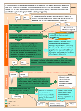
1. Planning applications on designated geological sites (i.e., geological Site of Special Scientific Interest (SSSI), Regionally Important Geological and Geomorphological Site (RIGS)), or applications near (within 50m) of a site that involve: excavation, soak aways, vegetation clearance or works which might impact future management of a geological feature, such as access requirements or opportunities to record geological features during construction.
- A planning application is submitted to the Local Planning Authority (LPA) and must be accompanied by a completed Wildlife and Geology Trigger List to be validated. The applicant is required to fill in the trigger list and identify whether their proposal is on or within 50m of a designated site geological site using:
- Where the Wildlife and Geology trigger list identifies that a geology report is required, the report shall be prepared by an appropriately qualified geologist (including with demonstrable experience in the relevant field of geology, such as Devonian palaeontology and stratigraphy, Permian stratigraphy and sedimentology, Variscan tectonic processes and structures or Quaternary stratigraphy and palaeontology). As a minimum, the report should include:
-
- Demonstration that the mitigation hierarchy has been followed (No reasonable alternative sites, adverse effects will be avoided where possible, unavoidable impacts will be mitigated or reduced and impacts that cannot be avoided or mitigated will be compensated, ensuring that development decisions will safeguard the natural environment).
- Identify the condition of the geological interest and any additional features which may require consideration and protection.
- Identify if the application proposals put the site at risk of damage or loss.
- Must make reference to the Geopark Condition Assessment and management recommendations for Torbay’s Geosites report (2019, as compiled by Dr. K.N. Page).
- Identify if further field exploration, drilling of boreholes and excavations are required to inform the full report.
- Consider and provides recommendations regarding access and interpretation (of the heritage, environment and geology of the site) as is appropriate to its location, including improvements to open access with on-site or digital interpretation or through establishment of procedures for access by arrangement for academic research and digital interpretation, if the site is privately owned sites and open access is not feasible.
Note: Any clearance to facilitate the survey will need to consider the geodiversity and biodiversity value of a site and adhere to all relevant legislation.
- The LPA will formally consult the Geopark Coordinator.
- For SSSI sites the LPA will consult Natural England as part of the formal consultation.
- For RIGS sites the LPA will consult the Devon RIGS group as part of the formal consultation.
- The Geopark will assess the Geology Report (available on the planning portal). In order to support the retention of the UNESCO designation, and in line with any recommendations within the appraisal, the Geopark may comment that it would welcome:
-
- The provision of a management plan containing clear goals for the management of identified features and defined areas of value to protect and enhance, commensurate with the sites importance, may be sought as a planning condition, prior to commencement of development. This maybe a stand-alone plan or may form part of a formal Landscape and Environmental Management Plan (LEMP).
- Contributions for site management, including access improvements and interpretation, may be sought as appropriate (in accordance with the Planning Contributions and Affordable Housing SPD).
- Where appropriate, continued academic access for research may be required (for sites where there is no public access) and some form of guarantee for such access may be sought
- A scheme of monitoring to be introduced.
Based on the material circumstances of the feature/site, the above will be adapted to individual cases as required and the Geopark will make further recommendations where appropriate following consultation with the full board should that be felt necessary.
See the Flow Chart in Figure 1 - please contact us if you would like this in an alternative format.
2. Planning applications on or near (within 50m) undesignated geological sites, new or temporary exposures of potential geological interest (old quarries, cliff faces, caves or cuttings) or applications that would expose a new geological feature.
As mentioned above, within Torbay there are eleven geological SSSIs and sixteen RIG Sites. It is known, however, that a number of sites of geological significance currently remain undesignated and unprotected, and these could be in the form of an old quarry, cliff face or cutting. In addition, sites subject to coastal erosion on the foreshore or cliff face may be affected by some activities[1]. Additionally, new works or road cuttings may temporarily or permanently expose new sites of significance. Should any of these scenarios be relevant then:
- A planning application is submitted to the Local Planning Authority (LPA) and must be accompanied by a completed Wildlife and Geology Trigger List to be validated. The applicant is required to fill in the trigger list to identify whether a development is on or near a potential site of interest or/and is likely to create a new exposure (see wildlife and geology trigger list).
- The Local Planning Authority will consult the Geopark and the Devon RIGS group at validation.
- The Geopark will make an assessment and comment whether a Geology Report is required (i.e. Steps 2 to 5 of the planning protocol above should be followed). See the flowchart in Figure 1
- Should features of significant geological interest or value be identified, the Geopark may additionally recommend to the RIGS group that the site be considered for designation. The Geopark may comment that planning seek appropriate funding to support this process through planning contributions.
[1] These may be identified in the South Devon and Dorset Shoreline Management Plan (SSDSMP), or within the Undeveloped Coast under Policy C3 of the Torbay Local Plan 2012-2030.
Geological terms and understanding
For clarity and to prevent misunderstandings, when considering Geopark comments, site surveys and when writing planning conditions, it is important to note the difference between structural safety and structural geological features. In particular, care should be taken to ensure the assessment and importance of structural geological features are not confused with aspects related to the structural safety of the site.
Structural safety – relates to the physical safety of the site in relation to loose rocks, the potential for landslide or rock fall or collapse and should be assessed separately by a structural engineer or geotechnical specialist.
Structural geological features– are the three-dimensional record in the rock that provide evidence of past tectonic activity, which is visible in the form of folds and faults of varying size and scale. Many sites in Torbay are of importance and designated because of their structural geological features. This geoscientific discipline is particularly relevant to the phase of tectonic activity at the end of the Carboniferous time period and the beginning of the Permian known as the ‘Variscan Orogeny’, and which is recorded in the limestones and other rocks of the Geopark as folds, faults and mineralised fissures. Such sites are a key aspect of the designation.
It should be noted that structural safety of a site is purely the responsibility of the site owner and that safety is of relevance to individual site designation and the contribution of that site to the retention of the UNESCO status. Both structural safety and structural geological features are of relevance to the retention of the UNESCO Global Geopark status.
More in About the council
- How the council works
- Councillors
- Leader of the Council
- Get in touch
- Voting and elections
- Consultations
- Finance and budgets
- Plans, policies and strategies
- Information and data
- Civic Mayor
- Pay an invoice
- Report fraud within or against the council
- Audit
- Achievements, Honours and Awards
- Climate Change
- Our Performance
- Greener Way for Our Bay